The Welcome to Bellevue Signs project identifies Bellevue City Limit locations with updated images. New signs were unveiled starting in 2018 to replace older signs installed in the 1980s. Below are descriptions of the scenes depicted in the signs. Map showing sign locations.
Coal Creek Waterfall

This Welcome to Bellevue sign features a photo of a Bellevue waterfall on Coal Creek, visible from the Coal Creek Trail.
The waterfall can be accessed by walking a short distance northwest on the Coal Creek Trail from the trailhead directly across Lakemont Boulevard from the Cougar Mountain Regional Park/Red Town Trailhead parking lot. The sign is located at the Bellevue city limits on Coal Creek Parkway and on Lakemont Boulevard. Photo credit: Marcus Donner.
Lewis Creek Park

Photo credit: Megan Eide (April 2018), an intern engineer with the Bellevue Transportation Department.
Bellevue Golf Course

In addition to beautiful tree-lined fairways and easy walking, the course sports a driving range, golf shop, teaching pros, and a restaurant.
The welcome sign is located near the golf course, on 140th and on 148th Avenue Northeast. Photo credit: John Johnson.
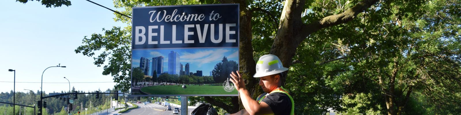
Bellevue Downtown Park

The signs are located at: Lake Washington Boulevard, north of Northup Way; at Northeast 24th Street and 98th Ave. Northeast; and at Lake Washington Boulevard and Northeast First Street. Photo credit: Megan Eide.
Lake Sammamish
Lake Sammamish forms the eastern border of Bellevue and is near the neighborhoods of

This sign is located at the north city limits on West Lake Sammamish Parkway (WLSP), near Northeast 24th Street, and also on WLSP near Interstate 90. Photo credit: BellevueHomes.com.
Bridle Trails

The photo was taken at Parkside Stables in the Bridle Trails neighborhood.
Photo credit: Parkside Stables
Northeast Bellevue
This sign will be placed north of 156th Avenue Northeast and Northeast Bel-Red Road,
It features the City of Bellevue logo. Bellevue was incorporated as a city in March 1953.
Future signs

Old signs
The older Welcome to Bellevue signs have been mostly removed
