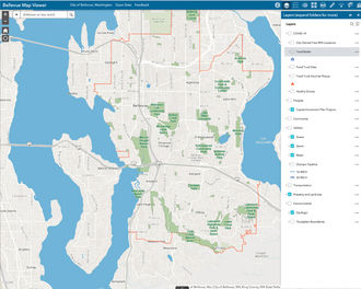
Bellevue offers a variety of standard PDF maps, downloadable spatial data and interactive web maps that help keep residents and visitors informed. Visit the full Map Gallery or preview featured interactive web maps below to explore city projects, plans and other city initiatives.
Please contact the Geospatial Technology Services (GTS) team with any questions, comments or suggestions about our map offerings.
Bellevue Map Viewer
Bellevue Map Viewer is an interactive map that allows the Bellevue community to access a variety of map layers such as parks and trails, capital projects, property information, utilities infrastructure, COVID-19 resources and more. The app has a variety of tools for tasks such as creating a printable PDF map, making measurements, or adding your own data and markup.
This viewer is mobile friendly so feel free to use it on your phone or tablet too, although some of the capabilities do work better on a larger device.
Building Bellevue
This map provides information about large building projects being designed for the Downtown and BelRed neighborhoods.
Trends in Transit
This tool helps monitor transit performance, presenting information about the number of people who get on/off the bus on average.
Welcome to Bellevue
Explore Bellevue's many public amenities including schools, community centers, parks, neighborhoods, emergency response, and voting districts.
Tech Startups
Browse local tech startup companies, co-working spaces, and incubator sites in Bellevue. Navigate the map's tabs to identify impacts and statistics.
New Zealand Mudsnails
This gives an overview of New Zealand Mudsnails' origin, migration patterns and impact. Find out what has been done to track, monitor and contain these mudsnails.
Community Resources | Mini City Hall
Locate local and regional services such as childcare, healthcare, energy and rental financial assistance, food, and affordable housing in proximity to the Crossroads area.
Vision Zero | Bellevue
This time-aware story map shows severity and locations of collisions involving pedestrians, bicyclists and motorists over a 10-year period.
Community Risk Assessment
Interactive map for viewing and identifying trends of response incidents, risks, and fire protection systems together with community info.