
Below you will find pre-made maps that are available for free download as well as links to additional resources. Pre-made maps are in portable document format (PDF) and can be viewed using a PDF reader such as Adobe Acrobat.
Questions
For information on a specific property's boundaries, please reference self-mapping applications such as King County's iMap and property search tool. Easement and other property inquiries can be directed to the Land Use Department.
Plat maps are available at the Service First Desk at City Hall. Assessor maps are available from the King County Assessor's Office.
General

Base Map (Small)
Public facilities, police and fire stations, transportation facilities, parks, schools, and streams (8" X 11")


Orthophoto Index
Reference grid used to select a specific orthophoto tile through the GIS Data Portal (11" X 17")


School District Boundaries
Boundaries of the Bellevue, Issaquah, and Lake Washington school districts (11" X 17")
Parks & Recreation

Trail Guide
Individual maps and detailed information of the 96 miles of trails maintained by the City of Bellevue

Park Guide
City of Bellevue Parks, open spaces, community facilities, and major trail systems (36" X 50")
Community Development

Annexation History
All annexations in Bellevue's history, with names of annexed areas (24" X 24")

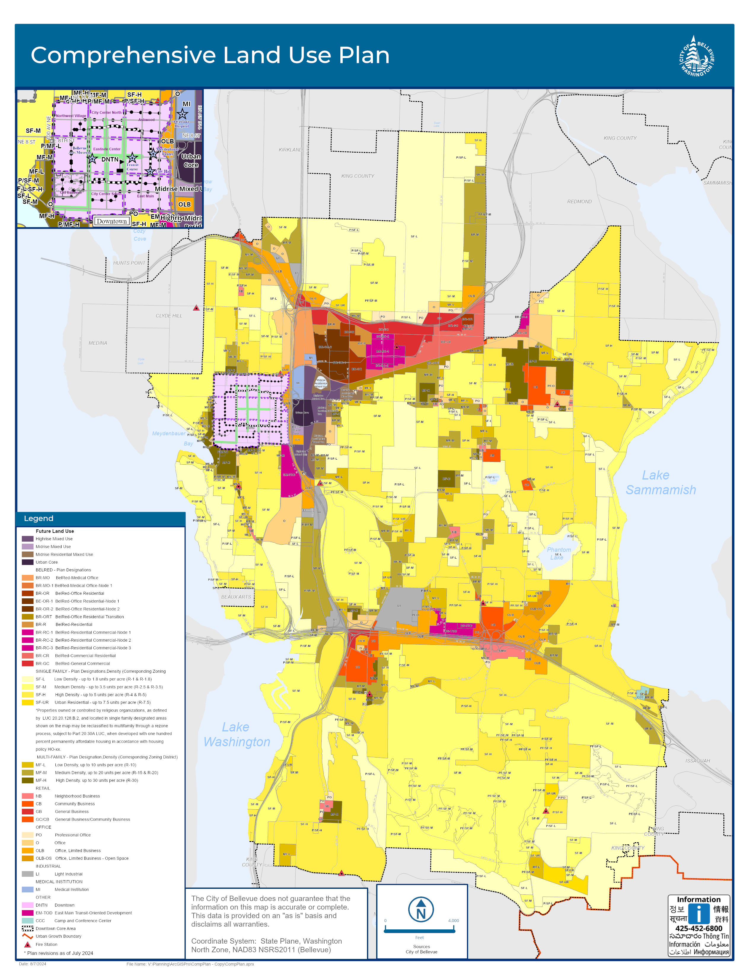
Comprehensive Plan
Citywide Comprehensive Plan classifications and street center lines (8" X 11")

Cultural Spaces
Cultural Spaces in Downtown with the Proposed Grand Connection Path (8" X 11")


Neighborhood Areas
Displays neighborhood areas, used for a variety of planning purposes such as outreach (8.5" X 11")

Subareas
Displays subareas, used for a variety of planning purposes such comprehensive planning (8" X 11")

Transportation

Arterial Classification
Major arterials and what classification is assigned to each (8" X 11")

Average Weekday Traffic
Traffic volumes at various locations throughout the city (11" X 17"). To view historic traffic data, click on this map (11" X 17")


Pavement Overlay Five-Year Program
Proposed plan for paving operations (11" x 17")


Trench Restoration
Classification for streets and type of pavement restoration required following any street cuts (36" X 48") or (11" x 17")

Downtown On-Street Parking
Locations of no-parking zones, 2-hour only parking, and charging stations for electric vehicles (8" X 11")