This page explains property boundaries and answers questions regarding the location of the right-of-way. You can locate your property boundaries without hiring a survey crew or having to consult city staff. For major projects, a professional surveyor will need to establish the boundaries for accuracy.
Right-of-way includes all public streets and property, together with public property reserved for public utilities, transmission lines and extensions, walkways, sidewalks, bikeways and equestrian trails.
Location of the right-of-way
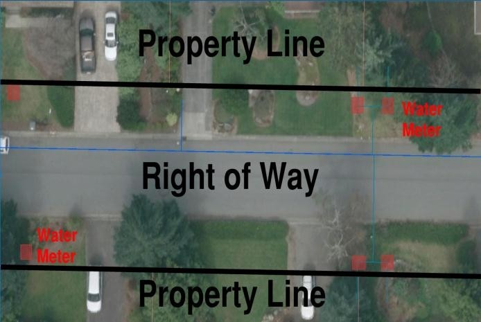
The location of city right-of-way is not determined by the width of the paved street. As a result, driveways, landscaping and walkways are sometimes installed in the right-of-way. Often, property owners mistake the edge of the roadway for the extent of their property. Most of the time the location of the right-of-way can be identified by locating a water meter. Water meters are usually placed outside the property, just within the right-of-way.
Lines indicate the extent of the property line, showing landscaping and trees within the right-of-way. Water meters are typically located within the right-of-way.
Working in the right-of-way
The private use of the public right-of-way requires a permit. Work in the right-of-way is considered private use of the right-of-way. In order to provide for the safety and general welfare of the public, removing trees or vegetation within the right-of-way requires prior authorization from the city. A permit is also required for disturbances or other private uses of the public right-of-way, including trenching, boring, replacement or modification of driveways, block parties, sidewalk cafes, and more.
Installation of structures in the right-of-way
Installation of mailboxes, fences, rockeries, or retaining walls must be approved by city officials because these objects may restrict sight distance or accessibility. The city may require the removal of unauthorized objects in the right-of-way.
Where can I find additional information?
You can find an aerial map of your property through this King County website in order to check your property boundaries. See http://gismaps.kingcounty.gov/parcelviewer2/
