Bellevue offers a variety of standard PDF maps, downloadable spatial data and interactive web mapping applications. Explore common city data layers using the Bellevue Map Viewer below or visit the full Map Gallery for focused, interactive web maps of city projects, plans and other city initiatives.
Please contact the Geospatial Technology Services team with any questions, comments or suggestions about our map offerings.
Bellevue Map Viewer
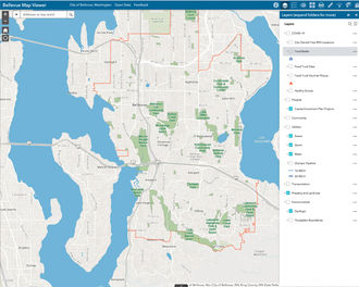
While the city maintains a variety of PDF and online maps, the Bellevue Map Viewer is particularly useful for many users, with layers for parks, trails, capital projects, utilities infrastructure, permit data and more. With the app, users can create printable PDF maps, make measurements or add their own data and markup.
This viewer is mobile-friendly, so feel free to use it on your phone or tablet, although some features work better on a larger device.
A short video offers instructions to help you get started with the app. You can use the Map Viewer any time.